Input
Regional seismic catalogs, usually from global seismic databases such as USGS, with historical and instrumental events.
SERRA/MEL transforms earthquake catalogs into physical energy histories, detects reactivation stages, maps seismogenic systems and translates energy concentration into engineering-oriented seismic risk parameters.
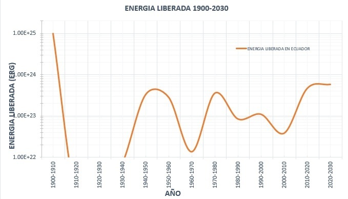
SERRA/MEL was developed between 1999 and 2000 during research activities connected to the University of Tokyo and earthquake engineering studies in Japan. Its conceptual foundation is the idea that seismic hazard should not be reduced only to magnitude statistics, but examined through the physical behavior of energy accumulation and release.
Regional seismic catalogs, usually from global seismic databases such as USGS, with historical and instrumental events.
Magnitude values are transformed into physical released energy using the inverse energy–magnitude relationship.
Energy curves, SIGSA maps, expected magnitude ranges, design acceleration estimates and seismic risk maps.
The first methodological step is to move from magnitude space into energy space. Because magnitude is logarithmic, it hides the enormous dominance of large events. In energy space, that dominance becomes visible and measurable.
SERRA treats the seismic catalog as a physical record of released tectonic energy.
Log(Es) = 1.5 · Ms + 11.8
Magnitude becomes energy; energy becomes a time series; the time series becomes the seismic fingerprint of the region.
Events are aggregated over time to construct energy-versus-time curves. These curves reveal periods of high release, recharge, recurrence, unusual concentration and potential reactivation.
Energy peaks identify seismic stages that may last years or decades depending on the scale of analysis.
Current energy levels can be compared with previous cycles to assess whether the region is below, near or above historical behavior.
Intervals between energy peaks can support probabilistic windows of future reactivation, without claiming exact earthquake prediction.
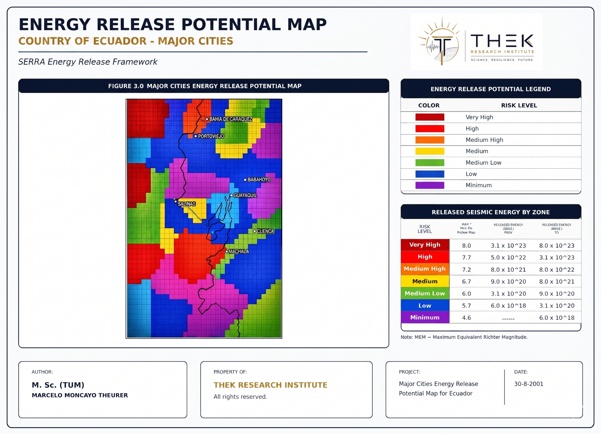
A SIGSA is an integrated seismogenic system. Instead of treating each fault as an isolated element, SERRA groups related fault structures and seismic activity into a spatial-energy source that can be analyzed through time, energy and distance.
This makes SERRA especially useful in tectonically complex regions, where risk is not always controlled by the closest fault or by simple subduction distance.
The method can also analyze how earthquakes distribute with depth over time. A central SERRA observation is that reactivation stages tend to be associated with greater superficial seismicity, while quiet periods tend to show deeper activity.
SERRA maps energy concentration spatially, estimates equivalent maximum magnitude, applies attenuation laws and produces parameters that can support seismic-resistant design and risk planning.
| Analytical stage | Meaning | Product |
|---|---|---|
| Catalog transformation | Magnitude to energy | Released-energy database |
| Temporal aggregation | Energy behavior through time | Energy release curves |
| SIGSA mapping | Energy by seismogenic system | Risk maps |
| Equivalent magnitude | Energy translated to event scale | Maximum Expected Magnitude |
| Attenuation | Motion expected at site | PGA / design acceleration |
THEK can present the SERRA workflow to universities, municipalities, engineering teams, risk managers and research partners.